


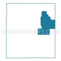
ALADDIN Voting District, Crook County, Wyoming
About
Outline

Summary
| Unique Area Identifier | 698573 |
| Name | ALADDIN Voting District |
| County | Crook County |
| State | Wyoming |
| Area (square miles) | 269.40 |
| Land Area (square miles) | 269.29 |
| Water Area (square miles) | 0.10 |
| % of Land Area | 99.96 |
| % of Water Area | 0.04 |
| Latitude of the Internal Point | 44.67738880 |
| Longtitude of the Internal Point | -104.21519850 |
Maps

Graphs
Select a template below for downloading or customizing gragh for ALADDIN Voting District, Crook County, Wyoming


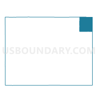
Neighbors
Neighoring Voting District (by Name) Neighboring Voting District on the Map
- ALVA Voting District, Crook County, WY
- BEULAH Voting District, Crook County, WY
- COLONY Voting District, Crook County, WY
- SUNDANCE OUTSIDE Voting District, Crook County, WY
- VTD - precinct 16 Minnesela, Butte County, SD
Top 10 Neighboring County Subdivision (by Population) Neighboring County Subdivision on the Map
- West Butte UT, Butte County, SD (2,686)
- Sundance CCD, Crook County, WY (2,602)
- Hulett CCD, Crook County, WY (1,211)
Top 10 Neighboring Unified School District (by Population) Neighboring Unified School District on the Map
Top 10 Neighboring State Legislative District Lower Chamber (by Population) Neighboring State Legislative District Lower Chamber on the Map
Top 10 Neighboring State Legislative District Upper Chamber (by Population) Neighboring State Legislative District Upper Chamber on the Map
Top 10 Neighboring 111th Congressional District (by Population) Neighboring 111th Congressional District on the Map
Top 10 Neighboring Census Tract (by Population) Neighboring Census Tract on the Map
- Census Tract 9677, Butte County, SD (7,138)
- Census Tract 9502, Crook County, WY (4,481)
- Census Tract 9676, Butte County, SD (2,972)
- Census Tract 9503, Crook County, WY (2,602)